

Cartographic Map of the British Isles
Cartographic Map of the British Isles
Couldn't load pickup availability
About the piece
About the piece
This vintage-style poster features a detailed cartographic map of the British Isles, highlighting cities, rivers, and topographical elements. Perfect for history enthusiasts, it captures the geographical essence of England, Scotland, Wales, and Ireland through precise, classic illustration. The muted tones and intricate lines make this a standout piece in any map or vintage illustration collection.
Product info
Product info
Printing
8 colour giclée print process on high-quality 230gsm archival matte paper. All our paper is FSC Certified and prints come with a lifetime fade-resistance guarantee.
Framing
Solid wood frames available in black stained or natural finishes, with UV resistant acrylic glass. Framed orders arrive pre-installed with your choice of print, ready to hang. Available in all print sizes.
Packaging
All orders are securely packed in recyclable, eco-friendly solutions. Frames are protected with sustainable bubble wrap alternatives inside thick boxes. Print only orders are shipped in heavy-duty cardboard tubes or protective hard-backed envelopes.
SKU: VIN-MAP-013
Shipping & returns
Shipping & returns
Every product is printed and framed to order, then shipped within 1 business day. We offer free standard delivery (3-5 working days) on orders over £50. Express shipping (1-2 working days) is also available at checkout.
If you’re not satisfied with your purchase, you may return it within 30 days of receipt, provided it remains unused and in its original condition.


Art made to last
-
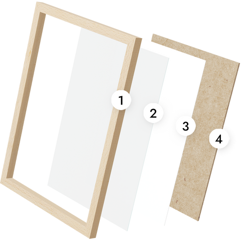
1 Solid wood frame
Sustainably sourced pine frames, manufactured in the UK. Available in natural or black stained finish.
-
2 Premium acrylic glass
High quality lightweight glaze, for safer transportation and a lighter load on your walls.
-
3 Museum quality print
8 colour gicleé print process on FSC-certified 200gsm archival matte paper, with lifetime fade-resistance guaranteed.
-
4 MDF backing board
Rigid board to seal your print in place & stiffen the frame, with fixings attached, ready to hang.

Why Animato?
- Choosing a selection results in a full page refresh.
- Opens in a new window.


